Displaying items by tag: xenogenesis
GPR Scanning of a farm finds a Viking ship
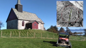
Ground Penetrating RADAR discovered a viking ship at Romsdal County in Norway. The ship dates back to the Viking period or Merovingian period. The length of the ship was between 50 to 55 feet, and more than 1000 years old. Traces of a settlement was also found along with burial mounds. The discoveries were made by archaeologists from the Norwegian LBI ArchPro. This is not the only ship they have located through GPR. To learn more about LBI and the discoveries they are making you can find them located here: https://archpro.lbg.ac.at/
GPR Concrete Scanning of Slab On Grade For Footer Location
GPR Concrete Scanning For Grade Beam Location Baldwin
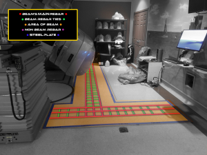
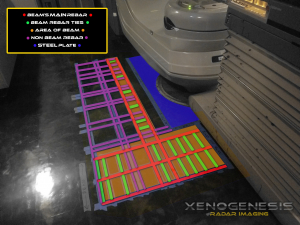
In this GPR Concrete Scanning job, we were able to locate the grade beams by the depth of the rebar and the presents of rebar ties or saddles. We were also about to locate the large metal plate reinforcing the floor for the heave medical machinery. GPR Concrete Scanning only needs access to one side of the slab, so unlike x-ray, it can make easy work of slab on grade applications.
Baldwin Plumbing Scan with GPR RADAR Scan of Concrete Slab
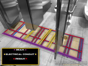
They needed to core 2 new holes in this area so we did some scanning and found them several places that were free of steel. One of the locations that were originally planned would have been right on top of a conduit this is another example of saving money but getting scanning.
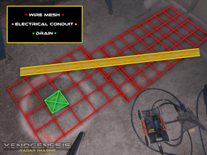
Baldwin Concrete Scanning Slab on Grade for Connecting To Drain
This conduit was in the path of a saw cut need to link up with the drain. Our GPR was able to locate it so the saw cutting company was able to chip around the conduit and avoid the issues that cutting this 240 volt line would have caused. GPR for Slab-on-Grade applications works very well for anything ran inside the slab. However, depending on the number of voids in the gravel layer locating runs in the dirt is not always possible. In this case, the conduit in the concrete was easy to locate, but the drain pipe under the slab ran in the dirt was not visible to GPR.
Ground Penetrating Radar - Archaeology - GPR - GPR Concrete Scanning - Geophysical Survey - Structural Analysis - GPR Concrete Scanning
