Call Or Email
(770) 569-1111
Click to Email

Utility Depth Profile of a Office Park Drain System
  • News

Utility Depth Profile

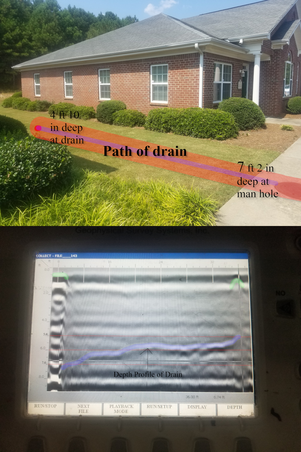
This is an example of locating and finding the exact profile depth of a Utility. First, the Location is found by running several passes at a 45-degree angle once we have mapped the location and path of the utility in question we can begin the depth profile pass. The distortion on the left-hand side of the screen is what we call ringing, in this case, it is caused by the metal hole cover (marked in green on the left) we went over at the very start of the Depth profiling pass. The drain vent (marked in green on the right) on the right side of the depth profile pass was made of plastic so the ringing effect did not occur. The Drain line is marked in blue and we can see the exact depth. This starts at 4 feet 10 inches at the point of the drain and runs down to 7 feet 2 inches where it meets the manhole. This is important to know because there is no problem running another utility in this same area such as Gas, Electric, or Fiber as these run 18 to 36 inches below the surface well within the safety zone of avoiding this drain pipe. Some times you have no choice but to cross utilities. Knowing the exact depth across the whole line can be a great help.

 Ground Penetrating Radar - Archaeology - GPR - GPR Concrete Scanning - Geophysical Survey - Structural Analysis  - gpr concrete scanning

NORTH CAROLINA
Charlotte city Raleigh city Greensboro city Winston-Salem city Durham city Fayetteville city Cary town Wilmington city High Point city Greenville city Asheville city

SOUTH CAROLINA
Charleston Columbia North Charleston Mount Pleasant Rock Hill Greenville Summerville Goose Creek Sumter Hilton Head Island Spartanburg Florence Myrtle

TENNESSEE
Nashville-Davidson Memphis Knoxville Chattanooga Clarksville Murfreesboro Franklin Jackson Johnson City Bartlett Hendersonville Kingsport Smyrna Collierville Cleveland


GEORGIA
Atlanta Augusta-Richmond County Columbus Macon-Bibb County Savannah Athens-Clarke County Sandy Springs Roswell Johns Creek Warner Robins Albany Alpharetta

ALABAMA
Birmingham Montgomery Huntsville Mobile Tuscaloosa Hoover Dothan Auburn Decatur Madison Florence Phenix City Prattville Gadsden Vestavia Hills Alabaster 

 Ground Penetrating Radar - Archaeology - GPR - GPR Concrete Scanning - Geophysical Survey - Structural Analysis  - GPR Concrete Scanning

© Copyright 2019, Baldwin RADAR Imaging llc. All Rights Reserved

Cron Job Starts